
Fouriesburg topographic map
Interactive map
Click on the map to display elevation.
About this map
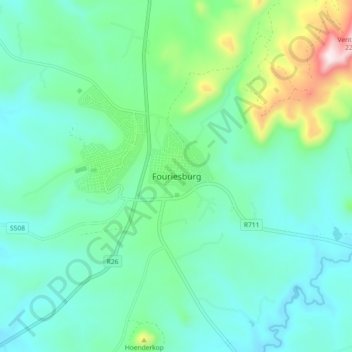
Name: Fouriesburg topographic map, elevation, terrain.
Average elevation: 5,725 ft
Minimum elevation: 5,272 ft
Maximum elevation: 7,398 ft
Other topographic maps
Click on a map to view its topography, its elevation and its terrain.
Sand River
South Africa > Free State > Thabo Mofutsanyana District Municipality > Dihlabeng Local Municipality
Sand River, Dihlabeng Local Municipality, Thabo Mofutsanyana District Municipality, Free State, South Africa
Average elevation: 5,299 ft
Bethlehem
South Africa > Free State > Thabo Mofutsanyana District Municipality > Dihlabeng Local Municipality
Bethlehem, Dihlabeng Local Municipality, Thabo Mofutsanyana District Municipality, Free State, 9700, South Africa
Average elevation: 5,495 ft
Botterkloof Dam
South Africa > Free State > Thabo Mofutsanyana District Municipality > Dihlabeng Local Municipality
Botterkloof Dam, Dihlabeng Ward 11, Dihlabeng Local Municipality, Thabo Mofutsanyana District Municipality, Free State, South Africa
Average elevation: 5,774 ft
Clarens
South Africa > Free State > Thabo Mofutsanyana District Municipality > Dihlabeng Local Municipality
Clarens, Dihlabeng Local Municipality, Thabo Mofutsanyana District Municipality, Free State, 9707, South Africa
Average elevation: 6,148 ft