
Kamia topographic map
Interactive map
Click on the map to display elevation.
About this map
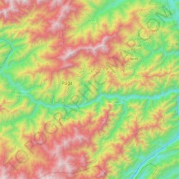
Name: Kamia topographic map, elevation, terrain.
Location: Kamia, Kamle, Arunachal Pradesh, India (27.74867 93.92564 27.81963 94.31719)
Average elevation: 3,789 ft
Minimum elevation: 394 ft
Maximum elevation: 8,455 ft
Other topographic maps
Click on a map to view its topography, its elevation and its terrain.
Yaja
India > Arunachal Pradesh > Taksing Circle
Yaja, Taksing Circle, Upper Subansiri District, Arunachal Pradesh, India
Average elevation: 9,052 ft
Tawang
India > Arunachal Pradesh > Tawang Circle
Tawang, Tawang Circle, Tawang District, Arunachal Pradesh, India
Average elevation: 10,761 ft
Pangin
India > Arunachal Pradesh > Pangin EAC
Pangin, Pangin EAC, Siang District, Arunachal Pradesh, 787052, India
Average elevation: 1,821 ft
Bolung
India > Arunachal Pradesh > Roing HQ > Bolung
Bolung, Roing HQ, Lower Dibang Valley, Arunachal Pradesh, India
Average elevation: 554 ft
Meka
India > Arunachal Pradesh > Roing HQ > Meka
Meka, Roing HQ, Lower Dibang Valley, Arunachal Pradesh, India
Average elevation: 965 ft