
Make a donation
Gear up for your next adventure:
As an Amazon Associate, this site earns from qualifying purchases at no extra cost to you.
Caimalito topographic map
Click on the map to display elevation.
Make a donation
Gear up for your next adventure:
As an Amazon Associate, this site earns from qualifying purchases at no extra cost to you.
About this map
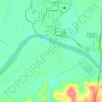
Name: Caimalito topographic map, elevation, terrain.
Average elevation: 2,959 ft
Minimum elevation: 2,867 ft
Maximum elevation: 3,159 ft
Make a donation
Gear up for your next adventure:
As an Amazon Associate, this site earns from qualifying purchases at no extra cost to you.
Other topographic maps
Click on a map to view its topography, its elevation and its terrain.
Guadacanal
Colombia > Risaralda > AMCO, Area Metropolitana Centro Occidente
Average elevation: 4,327 ft
Villa Colombia
Colombia > Risaralda > AMCO, Area Metropolitana Centro Occidente
Average elevation: 4,610 ft
Make a donation
Gear up for your next adventure:
As an Amazon Associate, this site earns from qualifying purchases at no extra cost to you.
Villa Cecilia
Colombia > Risaralda > AMCO, Area Metropolitana Centro Occidente
Average elevation: 4,288 ft
Monserrate
Colombia > Risaralda > AMCO, Area Metropolitana Centro Occidente
Average elevation: 4,941 ft
Universidad
Colombia > Risaralda > AMCO, Area Metropolitana Centro Occidente
Average elevation: 4,692 ft