Geolocate

Springfield topographic map

Click on the map to display elevation.

About this map

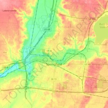
Name: Springfield topographic map, elevation, terrain.

Location: Springfield, Clark County, Ohio, United States (39.88786 -83.86966 39.98286 -83.70342)

Average elevation: 1,017 ft

Minimum elevation: 873 ft

Maximum elevation: 1,145 ft

Clark County trails, hiking, mountain biking, running and outdoor activities

Other topographic maps

Click on a map to view its topography, its elevation and its terrain.

Meadow Lane

United States > Ohio > Clark County

Average elevation: 1,040 ft

Pitchin

United States > Ohio > Clark County

Average elevation: 1,060 ft

Hustead

United States > Ohio > Clark County

Average elevation: 1,020 ft

Tiffany Acres

United States > Ohio > Clark County

Average elevation: 988 ft

Possum Woods

United States > Ohio > Clark County

Average elevation: 1,020 ft

Tiffany Acres

United States > Ohio > Clark County

Average elevation: 988 ft

Gear up for your next adventure:

🧦Merino Wool Socks - Moisture-wicking, blister-preventing socks for long treks
🚪Portable Camp Chair - Foldable chair for comfort at camp
👟Trail Running Shoes - Lightweight shoes for trail runners
🛠️Outdoor Gear Repair Kit - Essential tools to fix gear on the trail
📖Nature Tracking Books - Learn to track wildlife and terrain

As an Amazon Associate, this site earns from qualifying purchases at no extra cost to you.