
Keaton topographic map
Interactive map
Click on the map to display elevation.
About this map
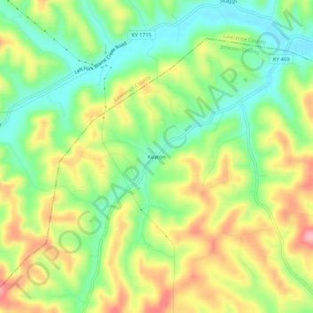
Name: Keaton topographic map, elevation, terrain.
Location: Keaton, Johnson County, Kentucky, 41226, United States (37.96564 -82.98017 38.00564 -82.94017)
Average elevation: 886 ft
Minimum elevation: 673 ft
Maximum elevation: 1,158 ft
Other topographic maps
Click on a map to view its topography, its elevation and its terrain.
Whitehouse
United States > Kentucky > Johnson County
Whitehouse, Johnson County, Kentucky, 41254, United States
Average elevation: 778 ft
Paintsville
United States > Kentucky > Johnson County
Paintsville, Johnson County, Kentucky, 41240, United States
Average elevation: 797 ft
Dawkins
United States > Kentucky > Johnson County
Dawkins, Johnson County, Kentucky, 41268, United States
Average elevation: 781 ft