
Gunung Argopuro topographic map
Interactive map
Click on the map to display elevation.
About this map
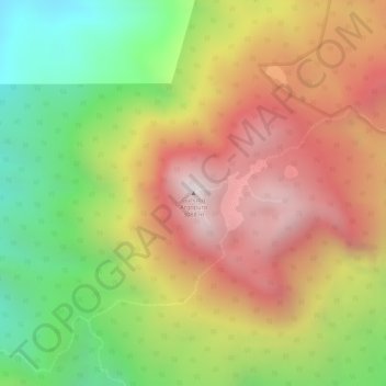
Name: Gunung Argopuro topographic map, elevation, terrain.
Location: Gunung Argopuro, Probolinggo, Ost-Java, Indonesien (-7.96445 113.56628 -7.96435 113.56638)
Average elevation: 8,675 ft
Minimum elevation: 7,060 ft
Maximum elevation: 10,075 ft
Other topographic maps
Click on a map to view its topography, its elevation and its terrain.
Banjarmendalan
Indonesien > Ost-Java > Banjarmendalan
Banjarmendalan, Lamongan, Ost-Java, 62211, Indonesien
Average elevation: 20 ft
Probolinggo
Indonesien > Ost-Java > Probolinggo
Probolinggo, Ost-Java, 62719, Indonesien
Average elevation: 187 ft
Semeru
Indonesien > Ost-Java > Malang
Semeru, Malang, Ost-Java, Indonesien
Average elevation: 10,161 ft
Gunung Ijen
Gunung Ijen, Banyuwangi, Ost-Java, Indonesien
Average elevation: 7,218 ft