
Zambezi National Park topographic map
Interactive map
Click on the map to display elevation.
About this map
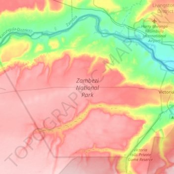
Name: Zambezi National Park topographic map, elevation, terrain.
Average elevation: 3,248 ft
Minimum elevation: 2,907 ft
Maximum elevation: 3,504 ft
Other topographic maps
Click on a map to view its topography, its elevation and its terrain.
Victoria Falls National Park
Zimbabwe > Matabeleland North > Victoria Falls
Victoria Falls National Park, Pioneer Road, Victoria Falls, Hwange, Matabeleland North, 00236, Zimbabwe
Average elevation: 2,995 ft