
Diriamba (Municipio) topographic map
Interactive map
Click on the map to display elevation.
About this map
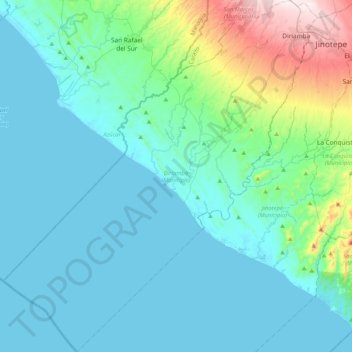
Name: Diriamba (Municipio) topographic map, elevation, terrain.
Location: Diriamba (Municipio), Carazo, 46300, Nicaragua (11.49292 -86.58358 11.89648 -86.21508)
Average elevation: 331 ft
Minimum elevation: 0 ft
Maximum elevation: 2,215 ft
The city's elevation (just above 500 meters above sea level), and the geography of the cordillera upon which it sits, lend it a constantly mild weather (though notoriously windy January through March).
Other topographic maps
Click on a map to view its topography, its elevation and its terrain.
San Marcos
Nicaragua > Carazo > San Marcos
San Marcos, San Marcos (Municipio), Carazo, 46400, Nicaragua
Average elevation: 1,841 ft