
Thank you for supporting this site ❤️
Make a donation
Make a donation
Gear up for your next adventure:
As an Amazon Associate, this site earns from qualifying purchases at no extra cost to you.
Les Anses-d'Arlet topographic map
Click on the map to display elevation.
Thank you for supporting this site ❤️
Make a donation
Make a donation
Gear up for your next adventure:
As an Amazon Associate, this site earns from qualifying purchases at no extra cost to you.
About this map
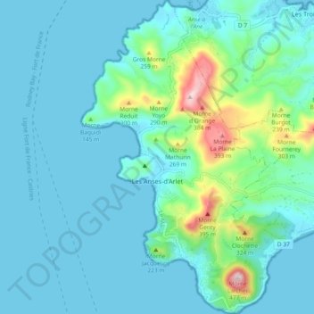
Name: Les Anses-d'Arlet topographic map, elevation, terrain.
Location: Les Anses-d'Arlet, Le Marin, Martinique, 97217, France (14.45385 -61.10092 14.54244 -61.04628)
Average elevation: 223 ft
Minimum elevation: -3 ft
Maximum elevation: 1,490 ft
Thank you for supporting this site ❤️
Make a donation
Make a donation
Gear up for your next adventure:
As an Amazon Associate, this site earns from qualifying purchases at no extra cost to you.