
Pike's Peak topographic map
Interactive map
Click on the map to display elevation.
About this map
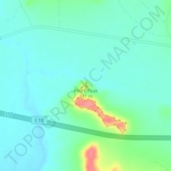
Name: Pike's Peak topographic map, elevation, terrain.
Location: Pike's Peak, Crockett County, Texas, United States (30.69790 -101.43711 30.69800 -101.43701)
Average elevation: 2,277 ft
Minimum elevation: 2,218 ft
Maximum elevation: 2,500 ft
Other topographic maps
Click on a map to view its topography, its elevation and its terrain.
Four Corner Windmill
United States > Texas > Crockett County
Four Corner Windmill, Crockett County, Texas, United States
Average elevation: 2,493 ft
Edwards Plateau
United States > Texas > Crockett County
Edwards Plateau, Crockett County, Texas, United States
Average elevation: 2,575 ft