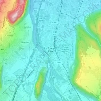
Le Pont-de-Claix topographic map
Interactive map
Click on the map to display elevation.
About this map
Name: Le Pont-de-Claix topographic map, elevation, terrain.
Average elevation: 945 ft
Minimum elevation: 732 ft
Maximum elevation: 1,719 ft

Click on the map to display elevation.
Name: Le Pont-de-Claix topographic map, elevation, terrain.
Average elevation: 945 ft
Minimum elevation: 732 ft
Maximum elevation: 1,719 ft