
Aiguille du Midi topographic map
Interactive map
Click on the map to display elevation.
About this map
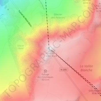
Name: Aiguille du Midi topographic map, elevation, terrain.
Average elevation: 10,161 ft
Minimum elevation: 6,385 ft
Maximum elevation: 12,405 ft
Other topographic maps
Click on a map to view its topography, its elevation and its terrain.
Chamonix-Mont-Blanc
France > Auvergne-Rhône-Alpes > Upper Savoy > Chamonix-Mont-Blanc > Chamonix-Mont-Blanc
Chamonix-Mont-Blanc, Bonneville, Upper Savoy, Auvergne-Rhône-Alpes, Metropolitan France, 74400, France
Average elevation: 5,863 ft
Refuge de L'Envers des Aiguilles
France > Auvergne-Rhône-Alpes > Upper Savoy > Chamonix-Mont-Blanc
Refuge de L'Envers des Aiguilles, Les Balcons de la Mer de Glace, Chamonix-Mont-Blanc, Bonneville, Upper Savoy, Auvergne-Rhône-Alpes, Metropolitan France, 74400, France
Average elevation: 8,356 ft
Aiguille Verte
France > Auvergne-Rhône-Alpes > Upper Savoy > Chamonix-Mont-Blanc
Aiguille Verte, Chamonix-Mont-Blanc, Bonneville, Upper Savoy, Auvergne-Rhône-Alpes, Metropolitan France, 74400, France
Average elevation: 10,577 ft
Mer de Glace
France > Auvergne-Rhône-Alpes > Upper Savoy > Chamonix-Mont-Blanc
Mer de Glace, Chamonix-Mont-Blanc, Bonneville, Upper Savoy, Auvergne-Rhône-Alpes, Metropolitan France, 74400, France
Average elevation: 7,615 ft