
Make a donation
Gear up for your next adventure:
As an Amazon Associate, this site earns from qualifying purchases at no extra cost to you.
Odd topographic map
Click on the map to display elevation.
Make a donation
Gear up for your next adventure:
As an Amazon Associate, this site earns from qualifying purchases at no extra cost to you.
About this map
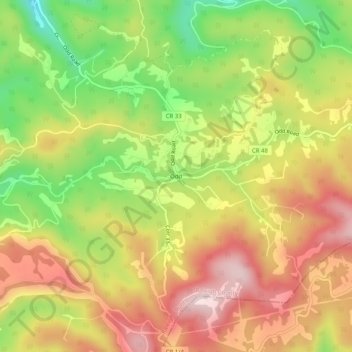
Name: Odd topographic map, elevation, terrain.
Location: Odd, Raleigh County, West Virginia, 25902, United States (37.57345 -81.21399 37.61345 -81.17399)
Average elevation: 2,822 ft
Minimum elevation: 2,201 ft
Maximum elevation: 3,366 ft
Raleigh County trails, hiking, mountain biking, running and outdoor activities
Make a donation
Gear up for your next adventure:
As an Amazon Associate, this site earns from qualifying purchases at no extra cost to you.
Other topographic maps
Click on a map to view its topography, its elevation and its terrain.
Make a donation
Gear up for your next adventure:
As an Amazon Associate, this site earns from qualifying purchases at no extra cost to you.
Shady Spring
United States > West Virginia > Raleigh County > Shady Spring
Average elevation: 2,743 ft
Make a donation
Gear up for your next adventure:
As an Amazon Associate, this site earns from qualifying purchases at no extra cost to you.