Geolocate

Bari topographic map

Click on the map to display elevation.

About this map
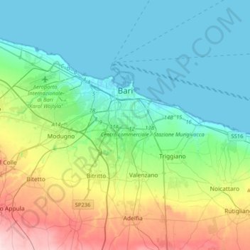
Name: Bari topographic map, elevation, terrain.

Location: Bari, Apulia, Italy (41.01606 16.71724 41.16978 17.03341)

Average elevation: 210 ft

Minimum elevation: -7 ft

Maximum elevation: 817 ft

Other topographic maps

Click on a map to view its topography, its elevation and its terrain.

Impalata

Italy > Apulia > Bari > Monopoli

Average elevation: 883 ft

Impalata

Italy > Apulia > Bari > Monopoli

Average elevation: 883 ft

Altamura

Italy > Apulia > Bari > Altamura

Average elevation: 1,342 ft

Polignano a Mare

Italy > Apulia > Bari

Average elevation: 138 ft

Monte Belvedere

Italy > Apulia > Bari > Altamura

Average elevation: 1,496 ft

Gear up for your next adventure:

🧣Merino Neck Gaiters - Multi-functional headwear for wind and sun protection
⛺Backpacking Tent - Lightweight and durable tent for multi‑day hikes
🧦Merino Wool Socks - Moisture-wicking, blister-preventing socks for long treks
🔥Plasma Lighters - Windproof lighters that work in any weather condition
🗺️NatGeo Topo Maps - High-quality waterproof printed topographic maps of US Parks

As an Amazon Associate, this site earns from qualifying purchases at no extra cost to you.