
Make a donation
Gear up for your next adventure:
As an Amazon Associate, this site earns from qualifying purchases at no extra cost to you.
Nablus topographic map
Click on the map to display elevation.
Make a donation
Gear up for your next adventure:
As an Amazon Associate, this site earns from qualifying purchases at no extra cost to you.
Nablus
Insofar as the hilly topography of the site would allow, the city was built on a Roman grid plan and settled with veterans who fought in the victorious legions and other foreign colonists. In the 2nd century CE, Emperor Hadrian built a grand theater in Neapolis that could seat up to 7,000 people. Coins found in Nablus dating to this period depict Roman military emblems and gods and goddesses of the Greek pantheon such as Zeus, Artemis, Serapis, and Asklepios. Neapolis was entirely pagan at this time. Justin Martyr who was born in the city c. 100 CE, came into contact with Platonism, but not with Christians there. The city flourished until the civil war between Septimius Severus and Pescennius Niger in 198–9 CE. Having sided with Niger, who was defeated, the city was temporarily stripped of its legal privileges by Severus, who designated these to Sebastia instead.
Make a donation
Gear up for your next adventure:
As an Amazon Associate, this site earns from qualifying purchases at no extra cost to you.
About this map
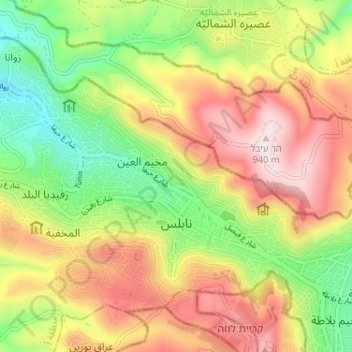
Name: Nablus topographic map, elevation, terrain.
Location: Nablus, Area A, West Bank, Palestinian Territories (32.20713 35.21811 32.24819 35.28262)
Average elevation: 2,116 ft
Minimum elevation: 1,227 ft
Maximum elevation: 3,077 ft
Make a donation
Gear up for your next adventure:
As an Amazon Associate, this site earns from qualifying purchases at no extra cost to you.
Other topographic maps
Click on a map to view its topography, its elevation and its terrain.
Bethlehem
Palestinian Territories > Area A
Bethlehem is located at an elevation of about 775 meters (2,543 ft) above sea level, 30 meters (98 ft) higher than nearby Jerusalem. Bethlehem is situated on the Judean Mountains.
Average elevation: 2,313 ft
Bethlehem
Palestinian Territories > Area A > Bethlehem
Bethlehem is located at an elevation of about 775 meters (2,543 ft) above sea level, 30 meters (98 ft) higher than nearby Jerusalem. Bethlehem is situated on the Judean Mountains.
Average elevation: 1,814 ft
Jenin
Palestinian Territories > Area A
Jenin is situated at the foot of the rugged northernmost hills (Jabal Nablus) of the West Bank, and along the southern edge of the Jezreel Valley (Marj Ibn Amer),[65] which the city overlooks.[66] Its highest elevation is about 250 meters above sea level and its lowest areas are 90 meters above sea level.[67]…
Average elevation: 636 ft
Make a donation
Gear up for your next adventure:
As an Amazon Associate, this site earns from qualifying purchases at no extra cost to you.
Bethlehem
Palestinian Territories > Area A
Bethlehem is located at an elevation of about 775 meters (2,543 ft) above sea level, 30 meters (98 ft) higher than nearby Jerusalem. Bethlehem is situated on the Judean Mountains.
Average elevation: 2,313 ft
Mount of Temptation
Palestinian Territories > Area A
The city of Jericho lies at the feet east of Mount Quruntul, at 258 m (846 ft) below sea level, with the nearby Jordan River and the Dead Sea at even lower elevations, further to the east and southeast. The mount has around 400 m (1,300 ft) of prominence over Jericho, which translates to an elevation of 138 m…
Average elevation: -161 ft
Make a donation
Gear up for your next adventure:
As an Amazon Associate, this site earns from qualifying purchases at no extra cost to you.
Bani Naim
Palestinian Territories > Area A
Bani Na'im (Arabic: بني نعيم, romanized: Banī Naʾīm) is a Palestinian town in the southern West Bank located 8 kilometers (5.0 mi) east of Hebron in the Hebron Governorate of the State of Palestine. It is situated at a higher elevation than most localities in the area, with an altitude of 951 meters…
Average elevation: 2,694 ft
Qabatiya
Palestinian Territories > Area A
Its entire land area is 50,547 dunams (50.5 km2; 19.5 sq mi), and its elevation is roughly 256 meters (840 feet). Qabatiya is famous for its olive groves, modern agriculture, and limestone industry.
Average elevation: 1,093 ft
Make a donation
Gear up for your next adventure:
As an Amazon Associate, this site earns from qualifying purchases at no extra cost to you.
Make a donation
Gear up for your next adventure:
As an Amazon Associate, this site earns from qualifying purchases at no extra cost to you.
Sanur
Palestinian Territories > Area A
Sanur is located in the highlands of the northern West Bank. The village is situated on an isolated hilltop along the western edge of the valley and seasonal lake of Marj Sanur, which is named after the village. To the west, Sanur is connected to the Hawarah Ridge of the Zawiya Highlands through a low-lying…
Average elevation: 1,388 ft
Make a donation
Gear up for your next adventure:
As an Amazon Associate, this site earns from qualifying purchases at no extra cost to you.