
Stavelot topographic map
Interactive map
Click on the map to display elevation.
About this map
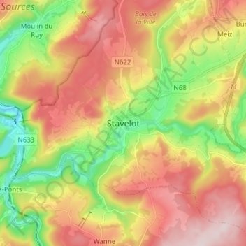
Name: Stavelot topographic map, elevation, terrain.
Location: Stavelot, Verviers, Luik, Wallonië, 4970, België (50.35424 5.89103 50.43424 5.97103)
Average elevation: 1,316 ft
Minimum elevation: 719 ft
Maximum elevation: 1,919 ft
Stavelot (Duits: Stablo, Waals: Ståvleu) is een stad aan de Amblève in de provincie Luik, arrondissement Verviers in België. De stad telt zo'n 7169 inwoners en ligt op een hoogte van 350m boven de zeespiegel.
Other topographic maps
Click on a map to view its topography, its elevation and its terrain.
La Vaulx Richard
België > Luik > Verviers > Stavelot
La Vaulx Richard, Stavelot, Verviers, Luik, Wallonië, 4970, België
Average elevation: 1,302 ft
Francorchamps
België > Luik > Verviers > Stavelot
Francorchamps, Stavelot, Verviers, Luik, Wallonië, 4970, België
Average elevation: 1,581 ft