
Děčín topographic map
Interactive map
Click on the map to display elevation.
About this map
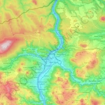
Name: Děčín topographic map, elevation, terrain.
Location: Děčín, okres Děčín, Ústecký kraj, Northwest, Czechia (50.70819 14.07778 50.86052 14.27165)
Average elevation: 1,145 ft
Minimum elevation: 390 ft
Maximum elevation: 2,359 ft
Děčín is located in northwestern Bohemia, at the confluence of the rivers Elbe and Ploučnice. The Elbe cut through the soft sandstone mountains of the region, and the city lies in the transition zone between Bohemian Switzerland and the Lusatian Mountains in the north and the Central Bohemian Uplands in the south. With the elevation of 135 metres (443 ft) in the river valley it is the lowest city in the country.