
Finsteraarhorn topographic map
Interactive map
Click on the map to display elevation.
About this map
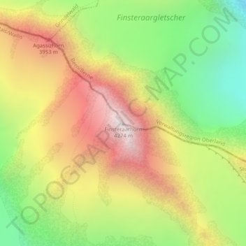
Name: Finsteraarhorn topographic map, elevation, terrain.
Location: Finsteraarhorn, Fieschertal, Goms, Valais/Wallis, Switzerland (46.53730 8.12606 46.53740 8.12616)
Average elevation: 11,220 ft
Minimum elevation: 8,780 ft
Maximum elevation: 13,796 ft
Other topographic maps
Click on a map to view its topography, its elevation and its terrain.
Grosses Fiescherhorn
Switzerland > Valais/Wallis > Fieschertal
Grosses Fiescherhorn, Fieschertal, Goms, Valais/Wallis, Switzerland
Average elevation: 11,178 ft