
Make a donation
Gear up for your next adventure:
As an Amazon Associate, this site earns from qualifying purchases at no extra cost to you.
Airdrie topographic map
Click on the map to display elevation.
Make a donation
Gear up for your next adventure:
As an Amazon Associate, this site earns from qualifying purchases at no extra cost to you.
Airdrie
Airdrie's name first appeared in the Register of the Great Seal of Scotland (Registrum Magni Sigilii Regum Scotorum) in 1373 as Ardre. By 1546 it had become Ardry and by 1587 it was known as Ardrie. In 1630 it finally appeared in the Register as Airdrie. Given the topography of the area, the most likely interpretation is that the name derives from the Gaelic An Àrd Ruigh meaning a level height or high pasture land. Another possibility is that it is from the Gaelic An Àrd Àirighe meaning a sheiling, a summer pasture/shepherd's hut. A third possibility is the Gaelic Ard Reidh meaning a high plain. A further, non-Gaelic alternative is the Brythonic, i.e. Cumbric or North Welsh, ard tref (becoming ardre by process of assimilation), meaning a high steading or farmstead, which would date back to the times of the Kingdom of Strathclyde, before the expansion of Gaelic or English speech into the region. Airthrey Castle in Stirlingshire may have a similar derivation.
Make a donation
Gear up for your next adventure:
As an Amazon Associate, this site earns from qualifying purchases at no extra cost to you.
About this map
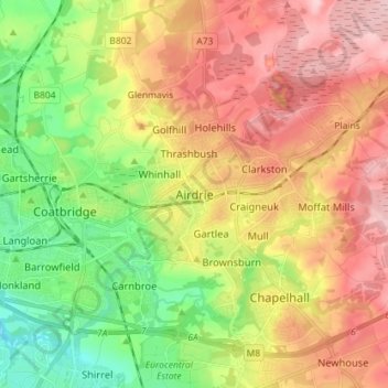
Name: Airdrie topographic map, elevation, terrain.
Location: Airdrie, North Lanarkshire, Scotland, ML6 6EQ, United Kingdom (55.82612 -4.02048 55.90612 -3.94048)
Average elevation: 443 ft
Minimum elevation: 154 ft
Maximum elevation: 748 ft
Make a donation
Gear up for your next adventure:
As an Amazon Associate, this site earns from qualifying purchases at no extra cost to you.
Other topographic maps
Click on a map to view its topography, its elevation and its terrain.
Cumbernauld
United Kingdom > Scotland > North Lanarkshire
Cumbernauld's name probably comes from the Gaelic comar nan allt, meaning "meeting of the burns or streams". There are differing views as to the etymology of this. One theory is that from its high point in the Central Belt, its streams flow both west to the River Clyde and east to the Firth of Forth so…
Average elevation: 371 ft
Make a donation
Gear up for your next adventure:
As an Amazon Associate, this site earns from qualifying purchases at no extra cost to you.
Forrestburn Reservoir
United Kingdom > Scotland > North Lanarkshire > Bentfoot
Average elevation: 758 ft
Cumbernauld
United Kingdom > Scotland > North Lanarkshire
Cumbernauld's name probably comes from the Gaelic comar nan allt, meaning "meeting of the burns or streams". There are differing views as to the etymology of this. One theory is that from its high point in the Central Belt, its streams flow both west to the River Clyde and east to the Firth of Forth so…
Average elevation: 371 ft