
Napa topographic map
Interactive map
Click on the map to display elevation.
About this map
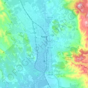
Name: Napa topographic map, elevation, terrain.
Location: Napa, Napa County, California, 94558, United States (38.22752 -122.35772 38.35083 -122.25492)
Average elevation: 282 ft
Minimum elevation: -13 ft
Maximum elevation: 1,860 ft
Napa County trails, hiking, mountain biking, running and outdoor activities
Other topographic maps
Click on a map to view its topography, its elevation and its terrain.