Geolocate

Springerville topographic map

Interactive map

Click on the map to display elevation.

Springerville

Springerville sits at an elevation of 6,974 feet (2,126 m) above sea level. Along with its neighbor Eagar, the communities make up the place known as Round Valley, which is in the central-eastern part of Arizona close to the New Mexico border.

Wikipedia (CC-BY-SA 3.0)

About this map

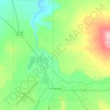
Name: Springerville topographic map, elevation, terrain.

Location: Springerville, Apache County, Arizona, United States (34.11833 -109.32331 34.19819 -109.24908)

Average elevation: 7,054 ft

Minimum elevation: 6,696 ft

Maximum elevation: 7,730 ft

Apache County trails, hiking, mountain biking, running and outdoor activities

Other topographic maps

Click on a map to view its topography, its elevation and its terrain.

Nutrioso

United States > Arizona > Apache County

Average elevation: 7,887 ft

Concho

United States > Arizona > Apache County

Average elevation: 6,050 ft

Spider Rock

United States > Arizona > Apache County

Average elevation: 6,411 ft

East Mesa

United States > Arizona > Apache County

Average elevation: 6,867 ft

Michigan Lake

United States > Arizona > Apache County

Average elevation: 6,194 ft

Red Rock

United States > Arizona > Apache County

Average elevation: 5,840 ft

Vernon

United States > Arizona > Apache County

Average elevation: 6,952 ft

Sawmill

United States > Arizona > Apache County

Average elevation: 7,723 ft

St. Michaels

United States > Arizona > Apache County

Average elevation: 6,778 ft

Concho

United States > Arizona > Apache County > Concho

Average elevation: 6,050 ft

Eagle Crag

United States > Arizona > Apache County

Average elevation: 6,463 ft

South Mountain

United States > Arizona > Apache County > Alpine

Average elevation: 8,911 ft