
Los Banos topographic map
Interactive map
Click on the map to display elevation.
Los Banos
Los Banos is located on the west side of the San Joaquin Valley, 26 miles (42 km) southwest of Merced, at approximately 118 ft (36 m) elevation. Its coordinates are 37°03′30″N 120°51′00″W / 37.05833°N 120.85000°W / 37.05833; -120.85000. The city is at the intersection of California State Route 152 and California State Route 165. 7 miles (11 km) to the west is Interstate 5, which runs north-to-south between Sacramento and Los Angeles. The San Luis Reservoir and the Diablo Range are farther to the west.
About this map
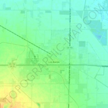
Name: Los Banos topographic map, elevation, terrain.
Location: Los Banos, Merced County, California, 93635, United States (37.04212 -120.89311 37.09253 -120.78699)
Average elevation: 115 ft
Minimum elevation: 85 ft
Maximum elevation: 171 ft
Merced County trails, hiking, mountain biking, running and outdoor activities
Other topographic maps
Click on a map to view its topography, its elevation and its terrain.
Hilmar
United States > California > Merced County
Hilmar is an unincorporated community in Merced County, California, United States. It is located 4.25 miles (6.8 km) west-southwest of Delhi, spanning 3.9 sq mi (10 km2) and at an elevation of 92 ft (28 m) above sea level. For census purposes, Hilmar is aggregated with a nearby community into the Hilmar-Irwin…
Average elevation: 98 ft
Delhi
United States > California > Merced County
Delhi (/ˈdɛlhaɪ/ DEL-hye) is a census-designated place (CDP) in Merced County in the U.S. state of California. Delhi is 18 miles (29 km) west-northwest of Merced, at an elevation of 118 feet (36 m). According to the 2020 census, the population was 10,656.
Average elevation: 128 ft