
Orinda topographic map
Interactive map
Click on the map to display elevation.
Orinda
The area is characterized by a warm-summer Mediterranean climate (Köppen climate classification Csb) with cool, rainy winters and warm, dry summers. Because Orinda is located in a hilly area, microclimates often dominate temperature differences in short distances. The Oakland Hills often block the cool foggy conditions that can be seen in Oakland and the innerbay. In the summer, fog can spill over the Oakland hills, cooling off the area. Heatwaves from the inland areas can be felt much more in Orinda than in Oakland and the innerbay during the summer. In the winter, Orinda often sees more precipitation than surrounding areas because of its higher elevation. Snowfall is rare but not unheard of. A dusting of snow may occur in any given year because of the elevation. During stable conditions in the winter, mornings can be cold and frosty in downtown and lower-lying areas, while the higher hills surrounding the area may be several degrees warmer.
About this map
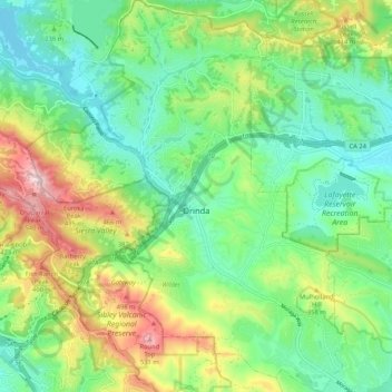
Name: Orinda topographic map, elevation, terrain.
Average elevation: 807 ft
Minimum elevation: 289 ft
Maximum elevation: 1,870 ft
Contra Costa County trails, hiking, mountain biking, running and outdoor activities
Other topographic maps
Click on a map to view its topography, its elevation and its terrain.
Montalvin Park
United States > California > Contra Costa County > Rollingwood
Average elevation: 171 ft
Lafayette Reservoir
United States > California > Contra Costa County > Lafayette
Average elevation: 571 ft
North Richmond
United States > California > Contra Costa County > North Richmond
Average elevation: 20 ft
Crolona Heights
United States > California > Contra Costa County > Crockett > Crolona Heights
Average elevation: 200 ft
Discovery Bay
United States > California > Contra Costa County > Discovery Bay
Average elevation: 0 ft