
Ashland topographic map
Interactive map
Click on the map to display elevation.
About this map
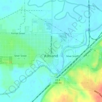
Name: Ashland topographic map, elevation, terrain.
Location: Ashland, Saunders County, Nebraska, 68003, United States (41.03190 -96.38756 41.04890 -96.35540)
Average elevation: 1,099 ft
Minimum elevation: 1,056 ft
Maximum elevation: 1,227 ft
Other topographic maps
Click on a map to view its topography, its elevation and its terrain.
Cedar Bluffs
United States > Nebraska > Saunders County
Cedar Bluffs, Saunders County, Nebraska, United States
Average elevation: 1,293 ft
Wahoo
United States > Nebraska > Saunders County
Wahoo, Saunders County, Nebraska, United States
Average elevation: 1,217 ft
Mead
United States > Nebraska > Saunders County
Mead, Saunders County, Nebraska, 68041, United States
Average elevation: 1,198 ft