
Dedham topographic map
Interactive map
Click on the map to display elevation.
Dedham
The first man-made canal in North America, Mother Brook, was created in Dedham in 1639. It linked the Charles River to the Neponset River. Although both are slow-moving rivers, they are at different elevations. The difference in elevation made the canal's current swift enough to power several local mills.
About this map
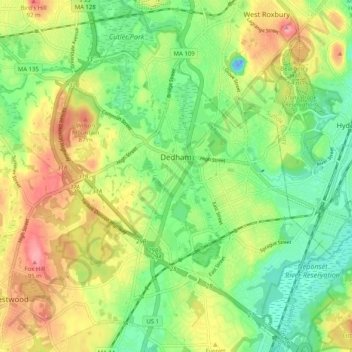
Name: Dedham topographic map, elevation, terrain.
Location: Dedham, Norfolk County, Massachusetts, United States (42.20922 -71.23172 42.28046 -71.13075)
Average elevation: 141 ft
Minimum elevation: -79 ft
Maximum elevation: 328 ft
Norfolk County trails, hiking, mountain biking, running and outdoor activities
Other topographic maps
Click on a map to view its topography, its elevation and its terrain.
Lake Massapoag
United States > Massachusetts > Norfolk County > Sharon
Because of the lake and the fact that Sharon is at a slightly higher elevation than the surrounding towns, and because it is located on the main rail line going south from Boston, the shores of the lake developed into a minor summer resort with several large hotels, summer camps and cottage colonies. Temple…
Average elevation: 276 ft
Clark Pond Reservoir
United States > Massachusetts > Norfolk County > Walpole
Average elevation: 213 ft
Crownridge Estates
United States > Massachusetts > Norfolk County > Medfield
Average elevation: 154 ft
Wrentham
United States > Massachusetts > Norfolk County > Wrentham > Wrentham
Average elevation: 259 ft
Wellesley Farms
United States > Massachusetts > Norfolk County > Wellesley > Wellesley Farms
Average elevation: 157 ft