Geolocate

Natchez topographic map

Click on the map to display elevation.

About this map

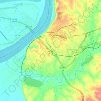
Name: Natchez topographic map, elevation, terrain.

Location: Natchez, Adams County, Mississippi, United States (31.50031 -91.42923 31.58854 -91.34308)

Average elevation: 131 ft

Minimum elevation: 39 ft

Maximum elevation: 315 ft

Adams County trails, hiking, mountain biking, running and outdoor activities

Gear up for your next adventure:

🏫Relief Map Kits - Hands-on tools for teaching landforms and elevation
📱Heavy-Duty Phone Cases - Drop-proof and waterproof protection for outdoor navigation
🥇GPS Hiking Watch - Multi‑sport GPS watch with navigation and trail tracking
🔭Telescopic Hiking Pole - Adjustable pole for hiking stability
🧥Men's Rain Shells - Premium waterproof and breathable jackets for mountain weather

As an Amazon Associate, this site earns from qualifying purchases at no extra cost to you.