
Vancleave topographic map
Interactive map
Click on the map to display elevation.
About this map
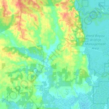
Name: Vancleave topographic map, elevation, terrain.
Location: Vancleave, Jackson County, Mississippi, 39565, United States (30.47313 -88.73354 30.61075 -88.60863)
Average elevation: 43 ft
Minimum elevation: -10 ft
Maximum elevation: 141 ft
Jackson County trails, hiking, mountain biking, running and outdoor activities
Other topographic maps
Click on a map to view its topography, its elevation and its terrain.
Marine Education Center
United States > Mississippi > Jackson County > Ocean Springs
Average elevation: 13 ft
Grand Bay Natural Wildlife Refuge
United States > Mississippi > Jackson County > Moss Point
Average elevation: 10 ft
Ocean Springs
United States > Mississippi > Jackson County > Ocean Springs > Ocean Springs
Average elevation: 13 ft