
Frederick topographic map
Interactive map
Click on the map to display elevation.
About this map
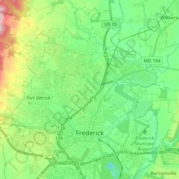
Name: Frederick topographic map, elevation, terrain.
Location: Frederick, Frederick County, Maryland, United States (39.39248 -77.47817 39.48854 -77.34531)
Average elevation: 367 ft
Minimum elevation: 46 ft
Maximum elevation: 1,158 ft
Frederick County trails, hiking, mountain biking, running and outdoor activities
Other topographic maps
Click on a map to view its topography, its elevation and its terrain.
West Frederick Highlands
United States > Maryland > Frederick County > Ballenger Creek
Average elevation: 371 ft
Highland
United States > Maryland > Frederick County
The majority of the downtown Highland district is situated within the 418-acre (169 ha) land grant named "Hickory Ridge". The Rouse Company borrowed the land grant name for one of its nearby villages of Columbia, built in 1974. The historic "White Hall" or "Hickory Ridge" estate (1749) was owned by the…
Average elevation: 1,171 ft
Mount Airy Estates
United States > Maryland > Frederick County > Mount Airy Estates
Average elevation: 528 ft
Colonial Heights
United States > Maryland > Frederick County > Thurmont > Colonial Heights
Average elevation: 515 ft