
Maplewood topographic map
Interactive map
Click on the map to display elevation.
About this map
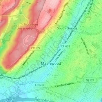
Name: Maplewood topographic map, elevation, terrain.
Location: Maplewood, Essex County, New Jersey, 07040, United States (40.71330 -74.29245 40.76057 -74.24312)
Average elevation: 279 ft
Minimum elevation: 82 ft
Maximum elevation: 600 ft
Essex County trails, hiking, mountain biking, running and outdoor activities
Other topographic maps
Click on a map to view its topography, its elevation and its terrain.
Saint Cloud
United States > New Jersey > Essex County > West Orange > Saint Cloud
Average elevation: 463 ft