
Tolland County topographic map
Interactive map
Click on the map to display elevation.
About this map
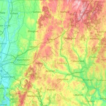
Name: Tolland County topographic map, elevation, terrain.
Average elevation: 489 ft
Minimum elevation: 3 ft
Maximum elevation: 1,306 ft
Capitol Planning Region trails, hiking, mountain biking, running and outdoor activities
Other topographic maps
Click on a map to view its topography, its elevation and its terrain.
Wickham Park
United States > Connecticut > Capitol Planning Region > Manchester
Average elevation: 131 ft
Whitings Corner
United States > Connecticut > Capitol Planning Region > West Hartford
Average elevation: 276 ft
Silvermine Acres
United States > Connecticut > Capitol Planning Region > Canton
Average elevation: 492 ft
Wapping
United States > Connecticut > Capitol Planning Region > South Windsor
Average elevation: 164 ft
Willington Hill
United States > Connecticut > Capitol Planning Region > Willington
Average elevation: 646 ft
Wormwood Hill
United States > Connecticut > Capitol Planning Region > Mansfield
Average elevation: 535 ft
Plantsville
United States > Connecticut > Capitol Planning Region > Southington
Average elevation: 180 ft
Milldale
United States > Connecticut > Capitol Planning Region > Southington
Average elevation: 167 ft
South Glastonbury
United States > Connecticut > Capitol Planning Region > Glastonbury
Average elevation: 157 ft
Hockanum
United States > Connecticut > Capitol Planning Region > East Hartford
Average elevation: 36 ft
Glastonbury Center
United States > Connecticut > Capitol Planning Region > Glastonbury
Average elevation: 89 ft
East Windsor Hill
United States > Connecticut > Capitol Planning Region > South Windsor
Average elevation: 52 ft
Thompsonville
United States > Connecticut > Capitol Planning Region > Enfield
Average elevation: 105 ft
Tariffville
United States > Connecticut > Capitol Planning Region > Simsbury
Average elevation: 210 ft
West Suffield
United States > Connecticut > Capitol Planning Region > Suffield
Average elevation: 167 ft
Suffield Depot
United States > Connecticut > Capitol Planning Region > Suffield
Average elevation: 138 ft
Stafford Springs
United States > Connecticut > Capitol Planning Region > Stafford
Average elevation: 656 ft
Mansfield City
United States > Connecticut > Capitol Planning Region > Mansfield
Average elevation: 482 ft
Halladay Corner
United States > Connecticut > Capitol Planning Region > Suffield
Average elevation: 138 ft
Elmwood
United States > Connecticut > Capitol Planning Region > West Hartford
Average elevation: 102 ft
Staffordville
United States > Connecticut > Capitol Planning Region > Stafford
Average elevation: 823 ft