
Middleborough topographic map
Interactive map
Click on the map to display elevation.
Middleborough
The nearest regional airports are Taunton Municipal Airport and Plymouth Municipal Airport, the nearest primary commercial airport is New Bedford Regional Airport, and the nearest national and international airports are T. F. Green Airport in Warwick, Rhode Island and Logan International Airport in Boston. From 1954 to 1959, a small runway called North Middleboro Airpark was constructed. It was a 3,000 foot-long paved runway, although it was not depicted in the November 1954 Boston Sectional Chart. Sometime between 1982–1994 it was closed, as it was depicted simply as "Landing Strip" on the 1994 USGS topographic map. A small grassy, unpaved field in South Middleborough is also used for recreational aircraft, but not for transportation.
About this map
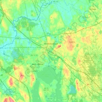
Name: Middleborough topographic map, elevation, terrain.
Average elevation: 79 ft
Minimum elevation: 3 ft
Maximum elevation: 226 ft
Plymouth County trails, hiking, mountain biking, running and outdoor activities
Other topographic maps
Click on a map to view its topography, its elevation and its terrain.
West Meadow
United States > Massachusetts > Plymouth County > West Bridgewater
Average elevation: 95 ft
Great Herring Pond
United States > Massachusetts > Plymouth County > Plymouth > Cedarville
Average elevation: 79 ft
Miles Standish Park
United States > Massachusetts > Plymouth County > Duxbury
Average elevation: 49 ft
Peddocks Island
United States > Massachusetts > Plymouth County > Hull > Fort Andrews
Average elevation: 3 ft
Arthur Thurbur Land
United States > Massachusetts > Plymouth County > Duxbury > Baileys Corner
Average elevation: 59 ft
Scotland Estates
United States > Massachusetts > Plymouth County > Bridgewater
Average elevation: 92 ft
Crescent Beach
United States > Massachusetts > Plymouth County > Mattapoisett
Average elevation: 16 ft
Fresh Pond
United States > Massachusetts > Plymouth County > Plymouth > Cedar Bushes
Average elevation: 46 ft
Cedarville Landing
United States > Massachusetts > Plymouth County > Plymouth
Average elevation: 52 ft
Marshfield Hills
United States > Massachusetts > Plymouth County > Marshfield > Marshfield Hills
Average elevation: 95 ft
Indian Heights
United States > Massachusetts > Plymouth County > Wareham > Indian Heights
Average elevation: 26 ft
Cranberry Village
United States > Massachusetts > Plymouth County > Carver > Cranberry Village
Average elevation: 98 ft
Kent Park
United States > Massachusetts > Plymouth County > Marshfield > Kent Park
Average elevation: 43 ft
Green Harbor River
United States > Massachusetts > Plymouth County > Marshfield > Green Harbor
Average elevation: 7 ft