
Limón topographic map
Interactive map
Click on the map to display elevation.
About this map
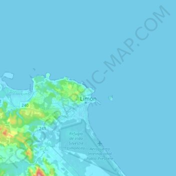
Name: Limón topographic map, elevation, terrain.
Location: Limón, Cantón Limón, Limón Province, 70101, Costa Rica (9.93829 -83.15854 10.06633 -83.00954)
Average elevation: 20 ft
Minimum elevation: -7 ft
Maximum elevation: 587 ft
Limón has an area of 59.51 km²[13] and an elevation of 3 metres.[2]
Other topographic maps
Click on a map to view its topography, its elevation and its terrain.
Valle La Estrella
Valle La Estrella, Cantón Limón, Limón Province, 70102, Costa Rica
Average elevation: 2,743 ft