
Grebin topographic map
Interactive map
Click on the map to display elevation.
About this map
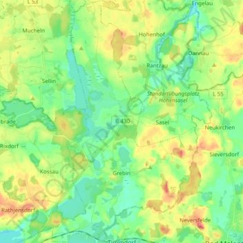
Name: Grebin topographic map, elevation, terrain.
Location: Grebin, Großer Plöner See, Plön, Schleswig-Holstein, Germany (54.17263 10.45054 54.26022 10.53889)
Average elevation: 131 ft
Minimum elevation: 49 ft
Maximum elevation: 266 ft
Other topographic maps
Click on a map to view its topography, its elevation and its terrain.
Hundestrand Brasilien
Germany > Schleswig-Holstein > Plön > Schönberg (Holstein) > Schönberger Strand > Brasilien
Average elevation: 0 ft