
Northeastern Region topographic map
Interactive map
Click on the map to display elevation.
About this map
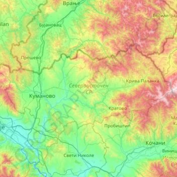
Name: Northeastern Region topographic map, elevation, terrain.
Location: Northeastern Region, North Macedonia (41.96054 21.43216 42.37390 22.51627)
Average elevation: 2,418 ft
Minimum elevation: 650 ft
Maximum elevation: 7,356 ft
Other topographic maps
Click on a map to view its topography, its elevation and its terrain.
Mount Korab
North Macedonia > Ribnica > Zhuzhnje
In addition to the Korab peak, there are several other, almost equally high elevations. North of the twin peaks are numerous other nameless, almost equally high rock towers. The peak about 2 km (1 mi) to the southwest, Korab-gate (Albanian: Maja e Portës së Korabit; Macedonian: Korapska Mala vrata) reaches…
Average elevation: 7,792 ft