
powiat piski topographic map
Interactive map
Click on the map to display elevation.
About this map
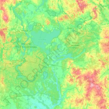
Name: powiat piski topographic map, elevation, terrain.
Location: powiat piski, Warmian-Masurian Voivodeship, Poland (53.45892 21.40884 53.90264 22.30564)
Average elevation: 440 ft
Minimum elevation: 344 ft
Maximum elevation: 692 ft
Other topographic maps
Click on a map to view its topography, its elevation and its terrain.
Majewo-Kolonia
Poland > Warmian-Masurian Voivodeship > Elbląg County > Majewo
Average elevation: 466 ft
Mrozy Małe
Poland > Warmian-Masurian Voivodeship > Ełk County > Mrozy Wielkie > Mrozy Małe
Average elevation: 417 ft