
St. Helier topographic map
Interactive map
Click on the map to display elevation.
St. Helier
The topography of the parish is one of the most varied. The marshland on which the town is situated is encircled by highlands which protect the town from the worst winds. In the southeast of the parish, rising from the plains in the centre of town, there is also Mont de Ville. This divides the Havre des Pas district from the Harbour.
About this map
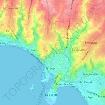
Name: St. Helier topographic map, elevation, terrain.
Location: St. Helier, Jersey (49.16785 -2.13694 49.21889 -2.08495)
Average elevation: 121 ft
Minimum elevation: -7 ft
Maximum elevation: 331 ft
Other topographic maps
Click on a map to view its topography, its elevation and its terrain.