
Paulhac topographic map
Interactive map
Click on the map to display elevation.
About this map
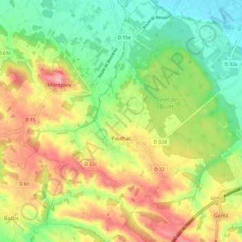
Name: Paulhac topographic map, elevation, terrain.
Average elevation: 541 ft
Minimum elevation: 341 ft
Maximum elevation: 794 ft
Other topographic maps
Click on a map to view its topography, its elevation and its terrain.
Toulouse
France > Occitania > Haute-Garonne > Toulouse
The first half of the 14th century was a prosperous period, despite the dismemberment in 1317 of the very large bishopric of Toulouse (which lost two thirds of its area and a large part of its income, a loss only partially compensated by its elevation to the rank of archbishopric), and the episode of the…
Average elevation: 568 ft