
Mohácsi járás topographic map
Interactive map
Click on the map to display elevation.
About this map
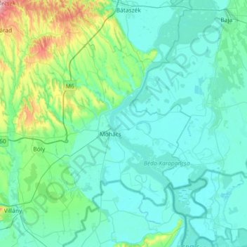
Name: Mohácsi járás topographic map, elevation, terrain.
Average elevation: 390 ft
Minimum elevation: 259 ft
Maximum elevation: 1,339 ft
Other topographic maps
Click on a map to view its topography, its elevation and its terrain.
Pécs
Pécs is bordered by plains to the south (elevation 120–130 m), while the Mecsek mountains rise up to elevations of 400–600 meters behind the city. Jakab-hill, located in the western Mecsek, is 592 m (1942 ft) tall, Tubes, straight above Pécs, is 612 m (2008 ft) tall, and Misina is 535 m (1755 ft) tall.…
Average elevation: 689 ft