
Stendal topographic map
Interactive map
Click on the map to display elevation.
About this map
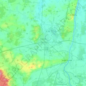
Name: Stendal topographic map, elevation, terrain.
Location: Stendal, Saksen-Anhalt, 39576, Duitsland (52.48477 11.56867 52.70079 11.97921)
Average elevation: 135 ft
Minimum elevation: 79 ft
Maximum elevation: 436 ft
Other topographic maps
Click on a map to view its topography, its elevation and its terrain.
Falkenberg
Duitsland > Saksen-Anhalt > Stendal > Altmärkische Wische
Falkenberg, Altmärkische Wische, Seehausen, Stendal, Saksen-Anhalt, Duitsland
Average elevation: 75 ft
Osterburg
Duitsland > Saksen-Anhalt > Stendal
Osterburg, Osterburg (Altmark), Stendal, Saksen-Anhalt, 39606, Duitsland
Average elevation: 95 ft