
Make a donation
Gear up for your next adventure:
As an Amazon Associate, this site earns from qualifying purchases at no extra cost to you.
Nicosia topographic map
Click on the map to display elevation.
Make a donation
Gear up for your next adventure:
As an Amazon Associate, this site earns from qualifying purchases at no extra cost to you.
About this map
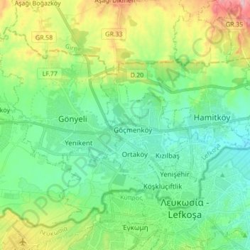
Name: Nicosia topographic map, elevation, terrain.
Average elevation: 548 ft
Minimum elevation: 344 ft
Maximum elevation: 1,056 ft
Make a donation
Gear up for your next adventure:
As an Amazon Associate, this site earns from qualifying purchases at no extra cost to you.
Other topographic maps
Click on a map to view its topography, its elevation and its terrain.
Make a donation
Gear up for your next adventure:
As an Amazon Associate, this site earns from qualifying purchases at no extra cost to you.
Vouno
The village of Vouno (meaning mountain in Greek) is located 10 kilometres north of Nicosia in Cyprus. Its name derives from the fact that it lies at an altitude of 380 meters above sea level and is the highest village on the south side of the Pentadaktylos mountain range. The village of Vouno is one of the 60…
Average elevation: 958 ft
Make a donation
Gear up for your next adventure:
As an Amazon Associate, this site earns from qualifying purchases at no extra cost to you.
Make a donation
Gear up for your next adventure:
As an Amazon Associate, this site earns from qualifying purchases at no extra cost to you.
Make a donation
Gear up for your next adventure:
As an Amazon Associate, this site earns from qualifying purchases at no extra cost to you.
Make a donation
Gear up for your next adventure:
As an Amazon Associate, this site earns from qualifying purchases at no extra cost to you.
Make a donation
Gear up for your next adventure:
As an Amazon Associate, this site earns from qualifying purchases at no extra cost to you.
Make a donation
Gear up for your next adventure:
As an Amazon Associate, this site earns from qualifying purchases at no extra cost to you.
Kyrenia
Another topographical source is the 'Stadiasmus Maris Magni' (from the name 'stadion', a unit measuring distances, 1 stadion = 184 metres). The unknown author, who sailed from Cape Anamur on the Cilician coast to Cyprus and circumnavigated the island, gave the distances from Asia Minor to the nearest point in…
Average elevation: 282 ft
Make a donation
Gear up for your next adventure:
As an Amazon Associate, this site earns from qualifying purchases at no extra cost to you.
Make a donation
Gear up for your next adventure:
As an Amazon Associate, this site earns from qualifying purchases at no extra cost to you.
Make a donation
Gear up for your next adventure:
As an Amazon Associate, this site earns from qualifying purchases at no extra cost to you.
Make a donation
Gear up for your next adventure:
As an Amazon Associate, this site earns from qualifying purchases at no extra cost to you.
Kyrenia
Another topographical source is the 'Stadiasmus Maris Magni' (from the name 'stadion', a unit measuring distances, 1 stadion = 184 metres). The unknown author, who sailed from Cape Anamur on the Cilician coast to Cyprus and circumnavigated the island, gave the distances from Asia Minor to the nearest point in…
Average elevation: 292 ft
Make a donation
Gear up for your next adventure:
As an Amazon Associate, this site earns from qualifying purchases at no extra cost to you.