Geolocate

Bielsko County topographic map

Interactive map

Click on the map to display elevation.

About this map

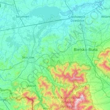
Name: Bielsko County topographic map, elevation, terrain.

Location: Bielsko County, Silesian Voivodeship, Poland (49.65280 18.82682 49.95892 19.31678)

Average elevation: 1,306 ft

Minimum elevation: 768 ft

Maximum elevation: 4,094 ft

Other topographic maps

Click on a map to view its topography, its elevation and its terrain.

Osiedle 100

Poland > Silesian Voivodeship > Bielsko County > Kozy

Average elevation: 1,332 ft

Łobodno

Poland > Silesian Voivodeship > Kłobuck County

Average elevation: 771 ft

Zbory

Poland > Silesian Voivodeship > Kłobuck County

Average elevation: 696 ft

Kleszczowa

Poland > Silesian Voivodeship > Zawiercie County

Average elevation: 1,109 ft

Pustkowie

Poland > Silesian Voivodeship > Myszków County > Jaroszów

Average elevation: 1,207 ft

Wygoda

Poland > Silesian Voivodeship > Zawiercie County > Rzędkowice

Average elevation: 1,234 ft

Mlyczek

Poland > Silesian Voivodeship > Pszczyna County > Łąka > Mlyczek

Average elevation: 843 ft

Zawiercie

Poland > Silesian Voivodeship > Zawiercie County > Zawiercie

Average elevation: 1,135 ft