
Cortona topographic map
Interactive map
Click on the map to display elevation.
About this map
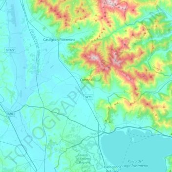
Name: Cortona topographic map, elevation, terrain.
Location: Cortona, Arezzo, Tuscany, Italy (43.15634 11.83351 43.37221 12.22465)
Average elevation: 1,230 ft
Minimum elevation: 781 ft
Maximum elevation: 3,488 ft
The prevailing character of Cortona's architecture is medieval with steep narrow streets situated on a hillside at an elevation of 600 metres (2,000 ft) that embraces a view of the whole of the Valdichiana. From the Piazza Garibaldi (still referred to by the local population by its older name, Piazza Carbonaia) is a fine prospect of Lake Trasimeno, scene of Hannibal's ambush of the Roman army in 217 BC (Battle of Lake Trasimene).
Other topographic maps
Click on a map to view its topography, its elevation and its terrain.
Bellavista
Italy > Tuscany > Arezzo > Ambra
Bellavista, Ambra, Bucine, Arezzo, Tuscany, 52021, Italy
Average elevation: 1,030 ft
Borgo alla Collina
Borgo alla Collina, Castel San Niccolò, Arezzo, Tuscany, 52018, Italy
Average elevation: 1,430 ft
Castelluccio
Castelluccio, Capolona, Arezzo, Tuscany, Italy
Average elevation: 853 ft
Vetrivecchi
Italy > Tuscany > Arezzo > San Giovanni Valdarno
Vetrivecchi, San Giovanni Valdarno, Arezzo, Tuscany, 52027, Italy
Average elevation: 518 ft
Loro Ciuffenna
Loro Ciuffenna, Arezzo, Tuscany, 52024, Italy
Average elevation: 1,975 ft
Montagnano
Montagnano, Monte San Savino, Arezzo, Tuscany, 52047, Italy
Average elevation: 843 ft
Pratovecchio Stia
Pratovecchio Stia, Arezzo, Tuscany, Italy
Average elevation: 2,808 ft
Pergine Valdarno
Pergine Valdarno, Laterina Pergine Valdarno, Arezzo, Tuscany, 52020, Italy
Average elevation: 1,027 ft
La Villa
Italy > Tuscany > Arezzo > Sansepolcro > La Montagna
La Villa, La Montagna, Sansepolcro, Arezzo, Tuscany, Italy
Average elevation: 2,608 ft
Santa Maria
Italy > Tuscany > Arezzo > Lucignano > Santa Maria
Santa Maria, Lucignano, Arezzo, Tuscany, 52046, Italy
Average elevation: 978 ft