Geolocate

Capolona topographic map

Click on the map to display elevation.

About this map

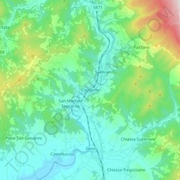
Name: Capolona topographic map, elevation, terrain.

Location: Capolona, Arezzo, Tuscany, 52010, Italy (43.50940 11.78027 43.61800 11.87850)

Average elevation: 1,378 ft

Minimum elevation: 669 ft

Maximum elevation: 4,003 ft

Other topographic maps

Click on a map to view its topography, its elevation and its terrain.

Pierle

Italy > Tuscany > Arezzo > Cortona

Average elevation: 1,867 ft

Giona

Italy > Tuscany > Arezzo > Bibbiena

Average elevation: 2,352 ft

Consuma

Italy > Tuscany > Arezzo > Montemignaio

Average elevation: 3,107 ft

Siregiolo

Italy > Tuscany > Arezzo > Chiusi della Verna

Average elevation: 2,359 ft

Vitiano

Italy > Tuscany > Arezzo > Arezzo > Rigutino

Average elevation: 961 ft

Caiano

Italy > Tuscany > Arezzo

Average elevation: 2,749 ft

Pulicciano

Italy > Tuscany > Arezzo

Average elevation: 1,693 ft

Soci

Italy > Tuscany > Arezzo > Bibbiena

Average elevation: 1,493 ft

Alberoro

Italy > Tuscany > Arezzo

Average elevation: 843 ft

Castelluccio

Italy > Tuscany > Arezzo

Average elevation: 853 ft

Montalto

Italy > Tuscany > Arezzo

Average elevation: 794 ft

Cortina

Italy > Tuscany > Arezzo

Average elevation: 2,530 ft

Villa

Italy > Tuscany > Arezzo > Villa

Average elevation: 2,707 ft

Gear up for your next adventure:

🏥Hiking First Aid Kits - Comprehensive medical kits for remote trail injuries
🩹Survival Bandages - High‑quality bandages for emergencies
🧭Hiking Compass - Precision compass for reliable navigation in the wilderness
🪵Folding Camp Saw - Compact saw for wood and campsite work
🛡️Bear Spray Outdoor - Protection in bear country hikes

As an Amazon Associate, this site earns from qualifying purchases at no extra cost to you.