
Oak Island topographic map
Interactive map
Click on the map to display elevation.
About this map
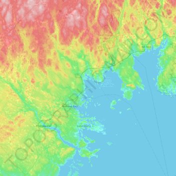
Name: Oak Island topographic map, elevation, terrain.
Average elevation: 243 ft
Minimum elevation: -7 ft
Maximum elevation: 932 ft
Other topographic maps
Click on a map to view its topography, its elevation and its terrain.
Oak Island
Canada > Nova Scotia > Lunenburg County > Western Shore
Oak Island, Western Shore, Chester District Municipality, Lunenburg County, Nova Scotia, B0J 3M0, Canada
Average elevation: 7 ft