
Bentley topographic map
Interactive map
Click on the map to display elevation.
About this map
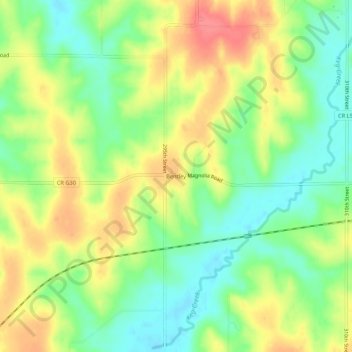
Name: Bentley topographic map, elevation, terrain.
Location: Bentley, Pottawattamie County, Iowa, 51548, United States (41.35694 -95.64028 41.39694 -95.60028)
Average elevation: 1,207 ft
Minimum elevation: 1,109 ft
Maximum elevation: 1,322 ft
Other topographic maps
Click on a map to view its topography, its elevation and its terrain.
McClelland
United States > Iowa > Pottawattamie County
McClelland, Pottawattamie County, Iowa, United States
Average elevation: 1,211 ft
Avoca
United States > Iowa > Pottawattamie County
Avoca, Pottawattamie County, Iowa, 51521, United States
Average elevation: 1,158 ft
Underwood
United States > Iowa > Pottawattamie County
Underwood, Pottawattamie County, Iowa, United States
Average elevation: 1,112 ft