
Mid Devon topographic map
Interactive map
Click on the map to display elevation.
About this map
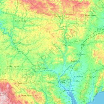
Name: Mid Devon topographic map, elevation, terrain.
Location: Mid Devon, Devon, England, United Kingdom (50.70315 -3.92591 51.03384 -3.14236)
Average elevation: 531 ft
Minimum elevation: -3 ft
Maximum elevation: 1,978 ft
Other topographic maps
Click on a map to view its topography, its elevation and its terrain.
White Cross
United Kingdom > England > Devon > Mid Devon > Cheriton Fitzpaine
Average elevation: 430 ft
St John's Chapel
United Kingdom > England > Devon > North Devon > Eastacombe
Average elevation: 256 ft
Bailey
United Kingdom > England > Devon > Mid Devon > Newton St. Cyres > Bailey
Average elevation: 299 ft