
Distrito David topographic map
Interactive map
Click on the map to display elevation.
About this map
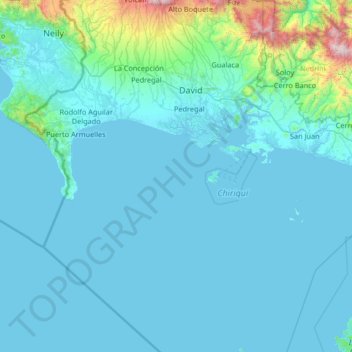
Name: Distrito David topographic map, elevation, terrain.
Location: Distrito David, Chiriquí, Panama (7.46329 -82.55959 8.77027 -82.20538)
Average elevation: 512 ft
Minimum elevation: -3 ft
Maximum elevation: 8,130 ft
Other topographic maps
Click on a map to view its topography, its elevation and its terrain.
Embalse Río Caldera
Panama > Chiriquí > Distrito de Boquete > Alto Boquete
Average elevation: 3,537 ft