
Austin topographic map
Interactive map
Click on the map to display elevation.
Austin
Austin is an unincorporated small town in, and former county seat of, Lander County, Nevada, United States. In 2020, the census-designated place of Austin had a population of 167. It is located on the western slopes of the Toiyabe Range at an elevation of 6,575 feet (2,004 m). U.S. Route 50 passes through the town.
About this map
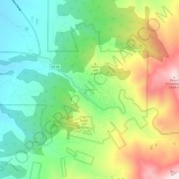
Name: Austin topographic map, elevation, terrain.
Location: Austin, Lander County, Nevada, United States (39.47326 -117.08954 39.51326 -117.04954)
Average elevation: 6,811 ft
Minimum elevation: 6,040 ft
Maximum elevation: 8,084 ft
Lander County trails, hiking, mountain biking, running and outdoor activities