
Pencil Lake topographic map
Interactive map
Click on the map to display elevation.
About this map
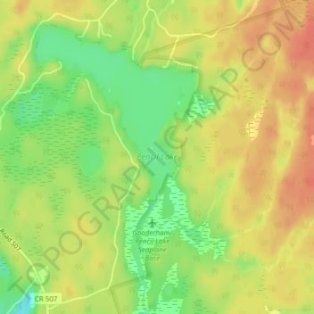
Name: Pencil Lake topographic map, elevation, terrain.
Average elevation: 1,093 ft
Minimum elevation: 1,004 ft
Maximum elevation: 1,152 ft
Other topographic maps
Click on a map to view its topography, its elevation and its terrain.
Buckhorn Lake
Canada > Ontario > Trent Lakes > Buckhorn
Buckhorn Lake, Fire Route 26a, Buckhorn, Trent Lakes, Peterborough County, Central Ontario, Ontario, K0L 1J0, Canada
Average elevation: 840 ft
Catchacoma Lake
Canada > Ontario > Trent Lakes
Catchacoma Lake, Fire Route 285, Trent Lakes, Peterborough County, Ontario, Canada
Average elevation: 1,001 ft
Catchacoma Narrows
Canada > Ontario > Trent Lakes
Catchacoma Narrows, Trent Lakes, Peterborough County, Central Ontario, Ontario, Canada
Average elevation: 991 ft
Nogies Creek
Canada > Ontario > Trent Lakes
Nogies Creek, Trent Lakes, Peterborough County, Central Ontario, Ontario, Canada
Average elevation: 1,070 ft
Nogies Creek
Canada > Ontario > Trent Lakes
Nogies Creek, Trent Lakes, Peterborough County, Ontario, Canada
Average elevation: 1,017 ft