
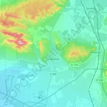
Eyguières topographic map
Interactive map
Click on the map to display elevation.
About this map
Name: Eyguières topographic map, elevation, terrain.
Average elevation: 440 ft
Minimum elevation: 184 ft
Maximum elevation: 1,565 ft
Other topographic maps
Click on a map to view its topography, its elevation and its terrain.
Mont Puget
France > Provence-Alpes-Côte d'Azur > Bouches-du-Rhône > Marseille
Average elevation: 948 ft
Crête de l'Estret
France > Provence-Alpes-Côte d'Azur > Bouches-du-Rhône > Marseille
Average elevation: 1,007 ft
Harry Potter
France > Provence-Alpes-Côte d'Azur > Bouches-du-Rhône > Marseille
Average elevation: 361 ft
La Merindole
France > Provence-Alpes-Côte d'Azur > Bouches-du-Rhône > Aix-en-Provence
Average elevation: 459 ft
Les Aspres
France > Provence-Alpes-Côte d'Azur > Bouches-du-Rhône > Pélissanne
Average elevation: 512 ft
Lo Val de Cuech
France > Provence-Alpes-Côte d'Azur > Bouches-du-Rhône > Salon de Provence
Average elevation: 453 ft
La Ciotat
France > Provence-Alpes-Côte d'Azur > Bouches-du-Rhône > La Ciotat > La Ciotat
Average elevation: 187 ft
Port-de-Bouc
France > Provence-Alpes-Côte d'Azur > Bouches-du-Rhône > Port-de-Bouc > Port-de-Bouc
Average elevation: 39 ft